There are 16 state gazetted Aboriginal or dual names in palawa kani, the language of Tasmanian Aborigines.
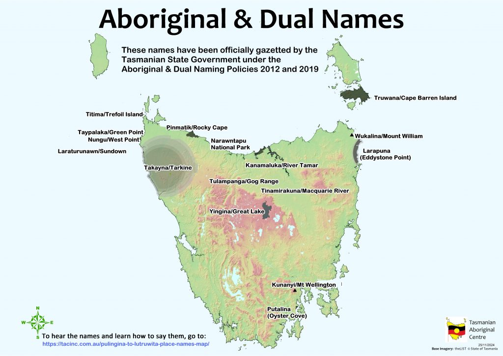
Fifteen of these names were assigned under the Aboriginal and Dual Naming Policy, which was adopted by the State Government in 2012 after many years of lobbying by Aborigines.
The names were proposed in separate submissions, with each list reviewed and put out for public comment by the Nomenclature Board (now renamed Placenames Tasmania). The first six names were gazetted in 2014, and another seven were gazetted in 2016. Another two names were gazetted in 2021 and then 2023. The names are to be shown on all official signage, maps and all official documents and publications (which is slowly but steadily occurring).
| Aboriginal / English name | Gazetted in |
| Truwana / Cape Barren Island | 2014 |
| Yingina / Great Lake | 2016 |
| Taypalaka / Green Point | 2016 |
| Kunanyi / Mt. Wellington | 2014 |
| Wukalina / Mt. William | 2016 |
| Kanamaluka / River Tamar | 2014 |
| Pinmatik / Rocky Cape | 2016 |
| Laraturunawn / Sundown Point | 2016 |
| Titima / Trefoil Island | 2016 |
| Takayna / The Tarkine | 2014 |
| Nungu / West Point | 2016 |
| Tulampanga / Gog Range | 2023 |
| Tinamirakuna / Macquarie River | 2021 |
Two Aboriginal names for unbounded localities appear as standalone (without an English name attached).
| Aboriginal name | Geographical area | Gazetted in |
| Larapuna | Bay of Fires | 2014 |
| Putalina | Oyster Cove | 2014 |
The above names were assigned by the Nomenclature Board under the Survey Coordination Act 1994.
The sixteenth name is Narawntapu National Park. It replaced the name Asbestos Range National Park in 2000, under the National Parks and Wildlife Act 1970.
Learn how to say the 16 official names
Kanamaluka / River Tamar – is the dual name for the river from its source in Launceston to its mouth at Low Head.
Kunanyi / Mount Wellington – is the dual name for the mountain above Nipaluna/Hobart.
Laraturunawn / Sundown Point – is in the northwest of Lutruwita.
Narawntapu (National Park) – central north coast, formally known as the Asbestos Ranges.
Nungu – West Point on the northwest coast.
Pinmatik / Rocky Cape – northwest coast.
Putalina – is an Aboriginal name for an unbounded locality covering the cove at Oyster Cove, the Aboriginal property previously known as “Oyster Cove”and adjacent lands with boundaries undefined.
Takayna / Tarkine – the dual name applies to the unbounded locality already named Tarkine in northwest Lutruwita.
Taypalaka / Green Point – in northwest Lutruwita.
Titima / Trefoil Island – island located off the northwest coast of Lutruwita.
Truwana / Cape Barren Island – dual name for the island which was returned to Aboriginal people in 2005.
Wukalina / Mt William – located in the northeast of Lutruwita.
Tulampanga / Gog Range –
Tinamirakuna / Macquarie River –
Lutruwita / Tasmania
Palawa / Tasmanian Aboriginal
